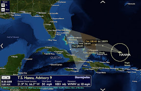
Atlantic Storm and Hurricane Track for Daytona Beach and Florida
Hurricane season is upon us once again. If you want to stay up to date with the latest storms forming over the Atlantic, The Daytona Post™ has implemented the most informative storm tracking and hurricane information resource on the web.
The Daytona Post™ has partnered with Stormpulse to provide the most interactive Hurricane and Storm tracking map. The well-rendered live map shows the current and projected tracks of all active named storms in the Atlantic basin. The storm information box shows wind speed and other parameters from the National Weather Service for any point in the storm track.
Through this site, you’ll be able to follow up on the many tropical storms and hurricanes that threaten the US coast. You’ll be able to see detailed information on them, like the wind speed, category, pressure, movement, and detailed graphics to keep them in check. You can choose to view the graphics in full screen mode. This makes the site a highly interactive way for you to get your weather updates.
Users can click on the map to zoom and pan for a better view. The map also offers the ability to display cloud cover and up-to-the-minute weather information from satellites, buoys, and more, plus 150 years of hurricane history of hurricane paths from as far back as 1851.
All of these resources come together on the site to make it one of the best Hurricane tracking experiences on the web. Don’t let another Hurricane sneak up on you.


Yes - We Support Hispanic Achiever's FL License Plate Request!